 Case study
Expanding IoT deployments with cost-effective Satellite IoT
7 Sep 2022 | 4 min read
Recent advances in technology have enabled IoT deployments to expand significantly, with ease, and at scale. Integrators and end-u...
22 November 2022
6 min read

INVOLI works with Astrocast to add satellite connectivity to its drone tracking solution. With complete traffic awareness and drone positioning information across the globe, commercial operators can expand drone usage for delivery, surveying and emergency support to even the most remote, unpopulated areas of the world.
The global commercial drone market is growing fast as organisations embrace the reliability and extended flying range of larger drones to support an array of new business cases – including the last mile of delivery and mining operations. With continuous and precise notifications, businesses can access challenging terrain, not only enabling the delivery of vital goods but also improving safety in hazardous environments. As a result, the global commercial drone market is expected to expand at a compound annual growth rate (CAGR) of 57.5% from 2021 to 2028.
The expansion of both fleets and geographic areas, however, raises its own challenges. How can firms ensure safety, meeting global regulatory demands to safeguard aviation aircrafts? How can companies manage and track entire drone fleets to optimise operations? Ever longer flights are Beyond Visual Line of Sight (BVLOS), what happens when a drone loses power or crashes? These are expensive pieces of equipment – costing up to $50,000; the ability to recover a lost drone is vital to creating a viable business case. Furthermore, with so many use cases located in rural and unpopulated areas, standard communications networks such as 4G are often unavailable, potentially limiting operations.
INVOLI, a Swiss-based expert in air traffic information and surveillance, has established its LEMAN Remote Identification Tracker as a key solution to commercial operators, providing visibility across an entire drone fleet.
“Our drone tracking and Remote ID solution enable commercial operators not only to track drone traffic in real-time via our web platform or using API, but also to comply with Remote ID international regulations.”
says Raphael Zaugg, Chief Technology Officer, INVOLI
The complete solution is a combination of a plug-and-play device with GPS, a Network Remote ID server, and a set of visualization, alerting, and API services, using 4G networks. Leman Remote ID Tracker can easily provide drone position, altitude, and speed during flight. INVOLI recognized the need to add satellite connectivity to its solution in April 2021 in order to provide connectivity across any global location. INVOLI and Astrocast started collaborated on a project initated by the European Space Agency (ESA) to develop a robust, lightweight solution for tracking drones in any location.
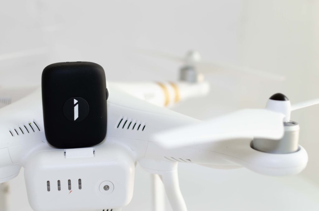
Antenna development was a vital aspect of the project. The tracker requires a satellite antenna that is both small and light enough to avoid drag or affect the drone in flight while also providing excellent connectivity, even if a drone crashed. Astrocast leveraged its extensive radio frequency expertise to undertake a custom antenna development for INVOLI.
“Antenna science is complex. It was vital to achieve the right balance of size and weight, as well as a wide aperture to maximise the satellite connectivity,”
explains Federico Belloni, Chief Technology Officer, Astrocast
A satellite connection requires the antenna to be pointing upwards, therefore the solution includes two antennas – one on either side of the drone – to provide 360-degree coverage in the event of a crash landing.
INVOLI has developed a new tracker platform that easily integrates with the Astrocast technology. To meet the needs of commercial drone operators, the solution is small, lightweight, and requires extremely low battery power usage. The process of integrating Astrocast into the INVOLI tracker was extremely straightforward.
“From an engineering point of view, adding Astrocast is as easy as integrating any connectivity module. Through its development and partner programs, Astrocast provides detailed technical information, documentation, and development modules, as well as access to teams of experts to support the integration process.”
explains Raphael Zaugg, Chief Technology Officer, INVOLI
As the commercial drone business model expands, especially BVLOS and automated flights, demands on operators will increase. A complex safety portfolio, as well as trusted access to robust surveillance data, will be required to demonstrate strategic and tactical mitigations of air and ground risks. With the addition of satellite connectivity, operators will have confidence that they will have continuous access to drone location data from anywhere in the world.
Cost is paramount – to safeguard the viability of the business case, the solution must be affordable.
“Astrocast’s solution works technically and cost-effectively. The other satellite options are far too expensive to justify, even for high-value drones. With this tracker, we can deliver an efficient solution that supports the drone operator’s business case.”
confirms Raphael Zaugg, Chief Technology Officer, INVOLI
INVOLI’s lightweight design ensures the tracker can be easily integrated with any drone – especially the heavier ones. Furthermore, by developing a solution with its own battery and connectivity, the tracker becomes independent of the drone. Even if the drone loses power, the tracker continues to function and provides location data, allowing operators to recover the expensive asset.
The tracking solution is also future-proofed through Astrocast’s bidirectional, cost-efficient satellite IoT solution. Currently, Involi is only transmitting information from the drone to the base station. However, the bidirectional functionality provides the opportunity to update firmware remotely if required. It could also be used to add the ability to terminate a drone in flight, should that be required by global air regulators in the future.
INVOLI’s Remote ID Drone Tracker is a critical component of its overall solution, which also includes visualization and data analytics to help commercial drone operators effectively manage the entire operation.
“The collaboration between Involi and Astrocast was excellent. The team spirit was aligned, and we worked together both virtually and physically sharing knowledge – and pizza – to achieve the right solution and deliver the next generation of drone tracking to the market.”
concludes Raphael Zaugg, Chief Technology Officer, INVOLI
By collaborating with Astrocast to incorporate satellite connectivity into the tracker, INVOLI is now able to provide drone operators with global air traffic awareness and positioning, opening the door to new use cases and the delivery of crucial services.
Case study
7 Sep 2022 | 4 min read
Recent advances in technology have enabled IoT deployments to expand significantly, with ease, and at scale. Integrators and end-u...
 Satellite IoT
23 Feb 2023 | 3 min read
Until now, many organisations – including System Integrators (SIs) and their end users – have struggled to cr...
 Press release
27 Jul 2022
Low power bidirectional Satellite IoT embedded into Soracom’s platform, offering connectivity in areas not covered by terrestria...